On May 10, 2021, the Village Board approved a contract with Christopher B. Burke Engineering (CBBEL) for the purpose of creating a Stormwater Master Plan. This was largely in response to substantial rainfall events that occurred throughout 2020. The main goal of the project is to assess the capacity of the Village’s combined sewer system regarding its ability to accommodate rain events of various severity.
On March 13, 2023, Staff from CBBEL presented their preliminary findings and conceptual Capital Improvement Plan (CIP) projects to the Village Board. The Village held a neighborhood meeting on August 1, 2023, which was open to the public. Though only a few residents attended, the informational material was presented, and their feedback was noted. Some of the main points of discussion included the following comments:
- The CIP projects identified are associated with very high costs.
- The Village should have a subsidy program that can help offset costs associated with stormwater improvements on private property.
Staff met with CBBEL in May of 2024 to discuss the SMP and how the plan could be finalized to include private property solutions as well as a prioritization of projects based on the costs of the projects versus the value of completion of the project. The report details the results of the completed Stormwater Master Plan (SMP), which includes the modeling analysis of the existing sewer system in addition to the proposed and analyzed capital improvement projects aimed at reducing flooding and improving the sewer system performance. Those project areas are described in this report as well as the accompanying exhibits. Concept-level cost estimates have also been prepared in addition to the previously mentioned prioritization plan. The plan was finalized in April 2025 incorporating changes provided by staff. Staff will continue to seek funding opportunities for these projects while also incorporating design elements found in the plan when developing any capital projects in the Village. The Final SMP can be found here, and the Appendix on Private Property Flooding Resources can be found here.
The purpose of this SMP is to:
- Determine the current levels of flood protection throughout the Village.
- Develop a prioritized Capital Improvement Plan that meets the desired protection level.
- Evaluate stormwater issues related to the Village’s ordinances and system maintenance.
- Provide resources to property owners to mitigate stormwater issues.
Existing Conditions
The Village was primarily developed prior to modern stormwater management practices. As such, there is limited stormwater storage, poor overland flow routes in rear yard areas and most notably a combined sewer system, none of which were designed based on current rainfall standards. It is unknown what rainfall standard, if any, was used in the original design. Industry standards for rainfall have been revised upward at least four times in the last half century. This means that when using the current standard, known as Bulletin 75, a storm or combined sewer must be increasingly larger compared to earlier rainfall standards to maintain the same design service level. The industry design standard for the sizing of a stormwater conveyance system is a 10-year storm event, which is an event that happens on average once in 10-years. An equivalent description is a storm that has a 10% chance of happening in a given year. Larger storm events, such as a 100-year event (1% annual chance), will exceed the capacity of the system and generate overland flow. Designing for a 100-year event is typically cost-prohibitive and can cost multiple times that of a 10-year design. Aside from cost, there tend to be other prevailing challenges such as depth, cover, and utility conflicts that come with larger pipe sizes.
There are three main watersheds within the Village, referred to as the North, Central, and South Area watersheds. The watersheds are shown on Figure 5 below:
The Village’s desire is to evaluate whether a 10-year LOP for basement flooding can feasibly be achieved. The 10-year criteria is considered an industry standard for the design of stormwater collection systems. While some circumstances may dictate the need for a higher standard, the 10-year standard is considered to be the best balance of project cost and level of protection. There are also physical limitations, in particular for a combined sewer system, that often prevent using a higher design standard. Depending on the relative elevations of the ground level, trunk sewers, MWRD interceptor sewers, basement floor, and the sewer service laterals, it is often not reasonably feasible to design a system to a higher level of protection on a Village-wide basin.
The Level of Protection (LOP) for much of the Village is a 2-year or less. Potential improvement projects were evaluated for each study area to gain a 10-year level of protection. Note that the projects developed were conceptual in nature and developed to understand the scope of improvements that would be needed; they are not necessarily recommended projects and did not consider cost effectiveness of each project. This would be completed during detailed design.
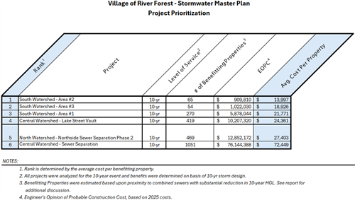
Summary of Projects
The following projects were conceptually developed to achieve a 10-year level of protection from basement flooding:
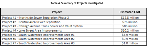
A prioritization process for ranking the conceptual projects was developed. This process often includes development of a Benefit-Cost Ratio (BCR) where damages are calculated for various types of flooding. A simplified approach was developed in which the model nodes (sewer manholes) that changed from red to either yellow or green in the flood mapping as a result of the project were identified. This change indicates that the conceptual project would create a significant reduction in the 10-year hydraulic grade line elevation and therefore reduce the frequency that basement flooding would occur. The properties in the vicinity surrounding each identified node were estimated and counted to determine the number of “benefitting properties”. The estimated project cost was divided by the number of benefitting properties to arrive at a cost-per-property. This metric is not intended to evaluate the cost effectiveness of the individual project but can be used to prioritize the projects against each other. The severity and type of flooding per property was not considered. Each project is individually reviewed in the Stormwater Master Plan. Exhibits for each project can be reviewed here.
Private Property / Resident solutions
The potential projects introduced in this report are large scale that would require extensive planning, funding, and implementation efforts. Green infrastructure manages stormwater on a very small scale. It generally does not provide the same level of flood protection as traditional stormwater management systems but can be a targeted solution that does reduce stormwater runoff and nuisance drainage problems. Over the last 20 years many communities throughout the region have increased implementation of green infrastructure by adding green infrastructure to their toolkit of approaches for the management of stormwater. Green infrastructure techniques include using vegetation and infiltration techniques to reduce stormwater impacts, restoring wetlands to retain runoff, installing permeable pavement to mimic natural hydrology, and using or capturing and re-using stormwater more efficiently on site. By attempting to mimic natural hydrologic functions, such as infiltration and evaporation, these approaches prevent stormwater from flowing into surface waters or sewer systems already under great stress. Green infrastructure is typically used to compliment or assist traditional stormwater management practices and is not meant to replace engineered “grey” or conventional stormwater management practices.
A majority of the Village is serviced by a combined sewer system, therefore stormwater not infiltrated into the ground or retained on site is ultimately collected in the sewers and sent to an MWRD wastewater treatment plant where it is then treated. The implementation of green infrastructure would incrementally reduce the amount of runoff that is sent to the combined sewer systems and help minimize combined sewer overflow (CSO) events. Green infrastructure practices cannot single-handedly mitigate Village-wide flooding during extreme storm events. This can be readily demonstrated by comparing the volume of water that ponds in streets and yards during a flood event with the comparatively small volume that can be held in rain barrels, infiltration areas, permeable paving, etc. However, despite these challenges, green infrastructure BMPs do provide a reduction in stormwater runoff volumes and improve water quality for more frequent storm events. Infiltration BMPs can be extremely useful for eliminating nuisance ponding in residential areas.
While this SMP report focuses primarily on the Village’s sewer systems, their capacities, potential improvements, etc., many of the drainage problems experienced within the Village occur on private property. Private property drainage problems within the Village can be generalized into three categories; basement backups, rear yard flooding, and riverine flooding.
Basement Back-up protection
As described throughout this report, the majority of homes within the Village are connected to a combined sewer system. Homes in a combined sewer area are generally at-risk of basement flooding when there is an unbroken gravity connection that drains household waste into the combined sewer. This unbroken system, i.e. no pumps or backflow prevention, was common for residential construction until at least the 1970s. In 1995, the Village initiated a subsidy program to help provide financial assistance to property owners interested in installing flood-prevention infrastructure. The program continues today. The intent of this program is to offset a portion of the expense that a property owner will incur when safeguarding their building from sewer back-ups. Residents should contact the Village for further details. Click here for the Informational packet regarding the program.
Rear Yard Flood Protection
A common problem for private properties within the Village, in particular residential properties, is poor drainage of rear yard areas. Other stormwater management methods that can be used in a rear yard setting include downspout disconnection, rain barrels, permeable pavement, and drywells. These three techniques provide temporary holding capacity for runoff in a way that is compatible with typical rear yard uses. There are many resources available to homeowners that describe each of these BMP techniques, how to choose and implement them, typical costs, etc. One highly recommended resource is produced by the Metropolitan Water Reclamation District of Greater Chicago and therefore is most relevant to the area. The MWRDGC’s Green Neighbor Guide, included in Appendix 3 of the SMP, is a manual that promotes responsible ways for homeowners to manage stormwater. These same techniques can serve to improve nuisance ponding or flooding in rear yard settings.
Riverine Flood Protection
While there is a major floodplain within the Village associated with the Des Plaines River, it is primarily located within undeveloped Forest Preserve land. There are limited areas where the floodplain impacts residential areas. One is a finger of 100-year floodplain that extends down Chicago Avenue and impacts the area near the intersection of Chicago and Thatcher Avenues. The second area is a residential pocket east of the river at Lake Street. This area is outside of the 100-year floodplain but within 500-year floodplain. It is protected by a partial levee system that must be manually extended across Lake Street when the river nears flood stage. Overall, the Village is well protected from riverine flooding with the exception of the two noted areas. A homeowner who wants to raise their level of protection from riverine flooding can generally consider two options: wet floodproofing and dry floodproofing. Wet floodproofing is applicable where the first floor of a house is above the flood elevation, but the basement level may be below and subject to flooding. Wet floodproofing seeks to modify the home’s mechanical and other systems and select compatible finishes that will incur relatively minor damage from a flood event. Dry floodproofing may be used where the flood elevation is higher than the first floor. It uses structural elements such as glass block windows, watertight doors, and other building modifications to withstand flooding.
The best available resource on floodproofing of structures is FEMA’s “Homeowner’s Guide to Retrofitting; Six Ways to Protect Your Home from Flooding”. Chapter 3.4 of this resource (Floodproofing) has been included in Appendix 3 of the SMP. The full document can be found here.
MWRD TARP PROJECT
The flat landscape of the Chicago region is naturally flood prone. Much of this area that is now home to over 5 million people was originally marshland with slow moving rivers and streams that would flood often.
Since it was founded in 1889, the Metropolitan Water Reclamation District (MWRD) has worked to reduce flooding and provide drainage for the Chicago region. MWRD has led the world in innovative flood control technology and has made major investments in vast infrastructure. The MWRD’s Tunnel and Reservoir Plan (TARP) reduces flooding by capturing water that would have otherwise overflowed from the sewer system into waterways. The water is held in TARP tunnels and reservoirs until after the rain passes and is pumped to water reclamation plants to be cleaned. By keeping this extra water out of waterways during rainy weather, TARP helps reduce flooding.
The TARP, also known as “Deep Tunnel,” is a system of deep, large-diameter tunnels and vast reservoirs designed to reduce flooding, improve water quality in Chicago area waterways and protect Lake Michigan from pollution caused by sewer overflows. TARP captures and stores combined stormwater and sewage that would otherwise overflow from sewers into waterways in rainy weather. This stored water is pumped from TARP to water reclamation plants (WRPs) to be cleaned before being released to waterways. The four TARP tunnel systems are designed to flow to three huge reservoirs, and the system will have a capacity of 17.5 billion gallons when complete. That is over 4,666 gallons for each person in its service area. One of the largest civil engineering projects on earth, TARP has been extremely effective and widely emulated since the initial tunnels went online in 1981. The Village of River Forest is directly serviced by the McCook Reservoir.
McCook Reservoir
A Project Cooperation Agreement (PCA) A PCA with the US Army Corps of Engineers USACE was signed on May 10, 1999, for the construction of the McCook Reservoir. The USACE is responsible for designing and constructing the reservoir features, and the District is responsible for providing the massive hole for the reservoir. Several construction contracts were completed by the USACE to turn the hole into a
reservoir, including construction of a groundwater cutoff wall and grout curtain around the reservoir perimeter, a construction shaft for the connecting tunnel, stabilization of rock highwalls, stabilization of soil and construction of retaining walls, distribution tunnels between the reservoir and the pumping station, main tunnels to connect the reservoir to the existing Mainstream Tunnel, the Final Reservoir Prep Contract to complete the distribution tunnel connection to the reservoir and install an aeration system, and addition of pumps and motors at the pumping station.
In October 2003, the District signed an agreement with a local mining company to mine out the limestone to the limits of the McCook Reservoir. Mining of Stage 1 was completed in 2016, and the first stage of the reservoir was made operational at the end of 2017, providing 3.5 billion gallons for storage of combined sewage. Since becoming operational, Stage 1 of the McCook Reservoir has captured approximately 130 billion gallons of combined sewage.
With Stage 1 now operational, Stage 2 construction will continue over the next several years while mining progresses. In 2006, the District decided to expand the federally-authorized 3.5 billion gallon capacity of Stage 2 of the reservoir to 6.5 billion gallons. Stage 2 of the reservoir is currently being mined and is approximately 72% excavated and is expected to be operational no later than 2032, pending market conditions for the sale of mined rock. The completed McCook Reservoir is estimated to provide more than $175 million per year in benefits to 3.1 million people in 37 communities including River Forest.
The Total Costs associated with the tunnels created is $2,332,000,000 while the costs associated with just the McCook Reservoir is $1,029,000,000.